Nakba 2.0: Lost Palestinian Villages

The term "Palestine refugees" originally referred to both Arabs and Jews whose normal place of residence had been in Mandatory Palestine but were displaced and lost their livelihoods as a result of the 1948 Palestine war. The UNRWA definition of the term includes the patrilineal descendants of the original "Palestine refugees". In 2012, there were an estimated 4,950,000 registered patrilineal descendants of the original "Palestine refugees", based on the UNRWA registration requirements, of which an estimated 1.5 million lived in UNRWA camps. The number of original refugees "who meet UNRWA’s Palestine Refugee criteria" was 711,000 in 1950 of which approximately 30,000 - 50,000 were still alive in 2012.During the 1948 Palestine War, around 85% (720,000 people) of the Palestinian Arab population of what became Israel fled or were expelled from their homes, to the West Bank, the Gaza Strip, and to the countries of Lebanon, Syria and Jordan. They, and their descendants, who are also entitled to registration, are assisted by UNWRA in 59 registered camps, 10 of which were established in the aftermath of the Six-Day War in 1967 to cope with new Palestinian refugees.
I am absolutely no fan of Zochrot with their Ethnicracy ( a neologism they invented) Solution for the Palestinian- Israeli Conflict whereby the solution is ethnic swamping by returning Palestinian refugees ( even a bigger fantasy than the Two State Solution) but at considerable expense they have developed iNakba pinpointing with GPS accuracy the Nakba.
https://inakba.org/

A click on iNakba, which the Zochrot NGO developed , reveals a hidden world and another side of Zion. One definitely not created by Zion. One created by the enermies of Zion when they broadcast to the Arab citizens of Palestine to flee , get out of the way so that the 680,00 Jews and their 1948 settlements could be bulldozed into the Mediterranean. These same Energies of Zion, Egypt, Jordan, Lebanon, Iraq and Syria never accept defeat and then gave the Hang Ten command to these Palestinian refugees to remain in their makeshift refugee camps and not return to their homes or disperse in the Arab Diaspora.
The 1948 Palestinian exodus, also known as the Nakba (Arabic: النكبة, "al-Nakbah", literally "disaster", "catastrophe", or "cataclysm") occurred when more than 700,000 Palestinian Arabs fled or were expelled from their homes, during the 1948 Palestine war.[2]The term "nakba" also refers to the period of war itself and events affecting Palestinians from December 1947 to January 1949.
“Begin the trip. Drive carefully,” the programmed voice said, adding not long afterward, “In another 200 meters turn left… You have reached your destination.” Destination? These the ruins of a Palestinian village amid thick undergrowth, in the middle of nowhere.

iNakba, a mobile app, was developed by Zochrot (an NGO that describes itself as promoting “Israeli Jewish society’s acknowledgement of, and accountability for, the ongoing injustices of the Nakba and the reconceptualization of Return as the imperative redress of the Nakba, and a chance for a better life for the entire country’s inhabitants.”) There are directions to the most hidden and most denied places in Israel. The Nakba in your iPhone. Zochrot is developing an Android iNakba app as well.
The app, subtitled “The Invisible Land,” is astonishing: sophisticated, thorough and knowledgeable, and user-friendly – if that’s the appropriate term for things related to Israel’s repressed past. One click and here’s the geography, another and you see the history, and yet another gets you a short video containing testimonies, if available, by refugees from the destroyed village in question. It’s a fascinating journey to this country’s archaeological past, one that is both the nearest to and most remote from the present day.
Enter the free app and a packed (and depressing) panoply of virtual pins covers the country. Each represents one of the more than 400 destroyed villages. And they’re everywhere: in the center of a city and at the far reaches of the country, buried under Jewish National Fund parks, nestled in the heart of a thriving moshav or a kibbutz, including the kibbutzim established by left-wing movements, of course. Clicking on the pin of your choice summons up the history of the village – number of residents, date of expulsion or flight – in Hebrew, Arabic or English. With the aid of Waze navigation technology (or Google Maps or Apple Maps), the app hurtles us into the lost but not necessarily buried past.
Journeys like this are just the thing for an Independence Day, or for any holiday or weekend outing. It’s a safari of ruins, a lesson in local history, an adventurous and highly educational Shabbat foray, obligatory for every fair-minded Israeli who is at least willing to learn and understand.
In the meantime, we’ve reached our first destination: the high sandstone cliff in the north of Tel Aviv, between Tel Baruch and Hatzuk beaches, until recently the site of an Israeli army base.
I’ve passed this place a thousand times but never knew that the hamlet of Sheikh Saeed al-Qurani had stood here. Date of occupation: April 1948. There’s no memorial or other form of commemoration here, only the vista of the turquoise-blue sea remains as it was, but inland the skyline of the city’s towers is very different from what existed in the sheikh’s time.
The tiles and construction refuse littering the site are not likely to have come from the village. There are condoms and garbage, tire marks of Israeli SUVs etched into the same, a bag from the Asian Home restaurant, the remnants of a barbecue that the guard at the base once organized here. Every sign becomes meaningful, anew. Consider “Danger, landslide, keep away,” for example.
On the eve of Independence Day, when the new application was launched, we drove in its wake along the coastline, northward from Tel Aviv. We visited remnants of some 12 villages. The app allows a far more extensive journey, a true passage to knowing the land.
Below the huge image of Theodor Herzl that looks down on coastal-road travelers from the heights of the water tower at the entrance to Herzliya, between a sea of Israeli flags and an electronic sign announcing “Memorial Day for the Fallen of the IDF and for the Victims of Hostile Acts,” lies another hamlet of victims of hostile acts.
We’ve arrived at Jalil al-Shamaliya, yet another former site of human habitation, until now invisible, though not really. Iron stairs lead into a tangle of bushes behind which the village was hidden, above today’s super-affluent Herzliya Pituah and the Herzliya high-tech zone. The village of 220 souls was taken over by the Alexandroni Brigade on April 1, 1948. Where are its residents and their descendants now? Does anyone care?
To the west, along Golda Meir Street and then left along Yigal Yadin Street, lies Al-Haram (also known as Sayyiduna Ali, or Sidna Ali), which had 600 residents in 1948. All that remains is the mosque compound, now beautifully renovated and abuzz – and the Muslim cemetery, forlorn and neglected, opposite the sea.
From there we head north, to Yakum Park, to another “You have reached your destination.” Actually, “reached your desolation” would be more accurate. Still, signs of former life peek through the vegetation, as though refusing to be obliterated – the last remnant of Khirbat al-Zababida. One house only, and it too is in ruins.
Through what was once a window we can see the villas of the “extension” of Yakum, a kibbutz once affiliated with the left-wing Hashomer Hatzair movement. “Tasty food to take home – the Kibbutz Yakum delicatessen,” reads one sign.
“Hazard reported along the way,” the Waze electronic voice tells us. We are already in a shabby neighborhood of Netanya, off Olei Hagardom Street. The population of the village of Umm Khalid, which once stood here, was 1,130.
What’s left of it now lies in the heart of the so-called City of Diamonds, which became the city of crime and the city of French immigrants. The ruins remain, a mute and untended monument near the top of the hill, blending in with construction refuse and vegetation. Probably no one here has ever heard of Umm Khalid, its ruins now punctuated with a sign from the Gates of Zion Institutions. The wall of one house is still visible, as is a stone wall, next to a parking area for ambulances and a preschool for religious children. “This site is private property,” says another sign – and indeed it is.

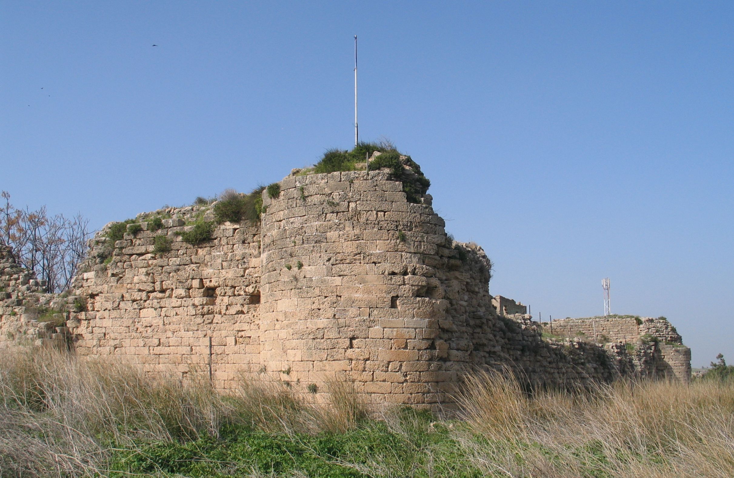
The Romans, of course, realised the benefits of plentiful fresh water in the Kabara valley and designed various methods by which to channel this water to the citizens of Caesarea, nearly five kilometers (3 miles) away. Whilst renovating the nature reserve preserve, excavators discovered a dam, which utilised three wooden floodgates to elevate the water, and control its flow through ground level aqueducts, chiseled out of stone by Roman crafstmen. The 200 metre long dam created a reservoir of 6000 dunams (about 2500 acres/ 1000 ha), creating a large lake in the Kabara valley with a virtually unlimited supply of fresh water fed by the stream, springs and runoff from the nearby Carmel mountains. As ever, the brilliant Roman engineering solution was very well constructed and a rebuilt version can be seen there today, as can the rebuilt Byzantine era waterwheel for the flour mill which used the power of the dammed river.
The ruins of Kabara are hidden in the Nahal Taninim nature reserve, those of Wadi al-Hawarith are on the lands of Moshav Geulei Teiman, and those of Qisariya in Caesarea National Park and a site to the east.
We have reached Tantura, which had 1,730 residents in 1948, and was – or was not – the site of a massacre. Gideon Bachrach was killed here in 1948, a soldier who was the only son of Drs. Binka and Arthur Bachrach, friends of my grandparents from their youth. I was named after him. Just now, though, hundreds of raucous youngsters are crowding the Hof Dor holiday resort, equipped with picnic hampers, narghiles, loudspeakers, darbukas, vodka, pita, hummus and meat. Holiday revelry.
We asked a guard where the mosque is, and she snapped at us angrily: “Mosque? What mosque? There’s no mosque here. Go to Fureidis” – a nearby Arab village. Finally she directed us toward the sheikh’s tomb on the seashore, the last remnant of Tantura, now lying under the lean-to of a meat-grilling Israeli family. “Hazardous structure, entry forbidden,” a sign again warns.

Moshav Habonim stands on the ruins of Kafr Lam. The secretariat building of the cooperative community was apparently the village school. A few ruins peek out from between the trees at the edges of the well-tended, peaceful community, close to the monument in memory of “our family members who perished in the Holocaust” and near archaeological excavations.
An elderly woman is hoisting the flag in front of the secretariat to its full height. On the eve of the 1948 war – a year before the moshav was founded – the village had a population of 390. iNakba has a video testimony of a village refugee; the woman relates how all the residents were placed on trucks and taken away.
Moshav Tzrufa nearby was founded a year later, in 1949. A biblical text is inscribed on the sign at the entrance: “The word of the Lord is pure [tzrufa]; He is a shield to all them that take refuge in him” (Psalms 18:30). But the name of this cooperative community is not taken from Psalms. It derives from the name of the Palestinian village, Al-Sarafand, on whose ruins it was built. The cemetery of Tzrufa lies opposite the cemetery of Sarafand, separated by the coastal highway.
It was here that we saw the most piteous sight. All that remains of the mosque is the floor, yet miraculously there were rolled-up carpets, folded chairs, bottles of water and paper cups there. People apparently still make pilgrimages here and continue to pray – in a mosque without a turret, without a ceiling and without walls, in which not a stone remains in place. An inscription has been spray-painted on the water tower next to the floor of the mosque: “And you shall love your neighbor as yourself – the whole Torah in a nutshell.”
Below, Israel Rail trains flash by. Not far away is the elegantly designed facility of Paradive, a “gallery of flight” and an “aerial reserve,” which has a runway for light planes and a school for skydiving.
A deathly silence prevails on the hill opposite the sea, broken only by the hiss of cars on the highway. The graves are mute, the sea breeze refreshing. The dead of Sarafand, the dead of Tzrufa and the Independence Day holiday-makers on Habonim beach – all of them constitute one image, engraved deep in the heart, very deep.
No comments:
Post a Comment